

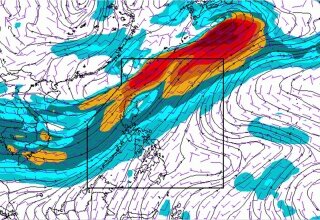
TUGUEGARAO CITY, Philippines- Tropical Depression Kiko has “maintained its strength as it moves towards extreme northern Luzon,” the state weather bureau said in its 5 pm update on Tuesday, September 5.
Northern Cagayan, Babuyan Group of Islands, Batanes remain under Storm Signal Number 1.
PAGASA said the tropical depression was last located 270 km East of Calayan, Cagayan and is moving North North-west at 19 kilometers per hour (kph). Kiko retained its maximum winds of up to 55 kph and gustiness of up to 65 kph.
Tomorrow afternoon, it is expected to be 155 km Northwest of Basco, Batanes. Kiko is expected to exit the Philippine Area of Responsibility (PAR) on Wednesday, September 6.
PAGASA said moderate to occasionally heavy rains is expected within 300 km diameter of the tropical storm. Residents in these areas advised to be alert against possible flashfloods and landslides.
They also warned fisherfolk and those with small seacrafts not to venture out over the eastern seaboard of northern and central Luzon due to approaching tropical depression. Northernforum.net


