
TUGUEGARAO CITY, Philippines- Tropical Depression Jolina has further intensified and now became a tropical storm as it threatens provinces of Cagayan Valley region.
In its weather bulletin issued 5 am on Friday, August 25, state weather bureau PAGASA said Jolina is expected to make landfall over Isabela on Friday evening.
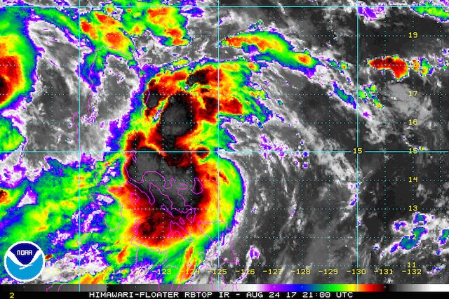
Karen has sustained maximum winds of up to 65 kilometers per hour (kph) and gustiness of up to 80 kph.
The following areas were place under signal number 2:
- Isabela
- northern Aurora
- Quirino
- Kalinga
- Mountain Province
- Ifugao
- Nueva Vizcaya
While these areas were put under signal number 1:
- Cagayan including Babuyan Group of Islands
- Apayao
- Ilocos Norte
- Ilocos Sur
- Abra
- La Union
- Benguet
- rest of Aurora
- Nueva Ecija
- Pangasinan
- northern Quezon including Polillo Island
- Catanduanes
- Camarines Norte
- Camarines Sur
The typhoon was last located at 300 kilometers East Southeast of Casiguran, Aurora and imoving West Northwest at a speed of 19 km/h.
The Philippine Atmospheric Geophysical and Astronomical Services Administration (PAGASA) warned residents at the low-lying areas of possible flashfloods and landslides as Jolina is expected to dump moderate to heavy rains in its 400-kilometer diameter.
Jolina is expected to leave the Philippine Area of Responsibility (PAR) on Saturday evening, August 26 in Ilocos area. TNF


